| Transport and Telecomms |
|
|
|
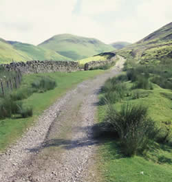 |
Roman
road, Durisdeer, Dumfries-shire |
The Roman occupation of Britain did not stop at Hadrian's Wall. Between AD 80-367 southern Scotland up to the Forth and Clyde was under their control, with advanced roads and forts as far north as Strathmore.
Their roads can still be traced in a few places. Principal amongst these were Dere Street, linking Midlothian to Corbridge, Northumberland, and a westerly route, exploiting the valleys of the Nith and Clyde. This is the route of the Roman road between Nithsdale and the Clyde, followed by a modern track, in the north east of Durisdeer, Dumfries-shire. |

Resource pack
|
 |
|
|


