|
||||||||
| Hamilton Palace (site), Hamilton, South Lanarkshire | ||||||||
 © RCAHMS |
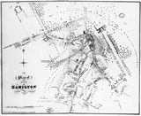
Plan of Hamilton, South Lanarkshire surveyed by John Wood, 1819 From at least the mid-15th century, the urban community which has developed into modern Hamilton grew up alongside the residence of the Lords (later Dukes of) Hamilton, and was very much under their authority. From the late 17th century onwards, that authority began to have an impact on the actual layout of the burgh and its physical relationship to the nearby palace. It was made manifest in a long process involving the removal of the townspeople from the 'Hietoun' of Hamilton which was clustered around the palace's western doorstep, and the consolidation of the area as private parkland. |
|||||||
|
This plan of the town of Hamilton as surveyed in 1819 is one in a series by John Wood and published as an atlas of Scottish towns between 1818 and 1828. It clearly shows the effect of the 9th Duke's recent enclosure programme as described by William Pettigrew's plan of 1813. A new wall has defined and re-shaped the eastern boundary of the burgh, distancing it from the palace grounds (right). A new route to the bridge over the River Clyde swings across the great avenue at a suitable distance from the palace, and urban settlement is beginning to stretch out in all directions away from the palace and its gardens. A surviving element of the 'Hietoun' was the tolbooth, here marked 'jail', which still served as the burgh council chambers, standing in the centre of what had been the High Street athwart the main entrance to the palace. Built in 1643, it continued to serve as town steeple, burgh council chambers and burgh prison until about 1834 when new municipal premises were established further up the hill. By 1846 both tolbooth and steeple had become the property of the 10th Duke of Hamilton (1767-1852), and the whole of the former 'Hietoun' had been walled off from the burgh. |
||||||||
|
|
|
|
|
|
|
|
|
|
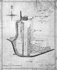
 Detailed
view of the palace Detailed
view of the palace |
||||||||
| |
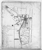 William
Pettigrew plan, 1813 William
Pettigrew plan, 1813 |
|||||||
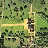
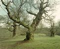 Cadzow Oaks |
 Engraving
by John Slezer Engraving
by John Slezer |
|||||||
|
|
|
|
|
|
|
|
|
|