 |
||||||||
| Hamilton Palace (site), Hamilton, South Lanarkshire | ||||||||
 © Lennoxlove House Ltd |
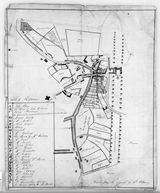
Copy of plan of improvements by William Pettigrew From at least the mid-15th century, the urban community which has developed into modern Hamilton grew up alongside the residence of the Lords (later Dukes of) Hamilton, and was very much under their authority. From the late 17th century onwards, that authority began to have an impact on the actual layout of the burgh and its physical relationship to the nearby palace. It was made manifest in a long process involving the removal of the townspeople from the 'Hietoun' of Hamilton which was clustered around the palace's western doorstep, and the consolidation of the area as private parkland. This copy plan of 1813 shows how the Hamilton estate dealt with the lower part of the 'Hietoun' of Hamilton which closely impinged upon the precincts of the palace (right). A new route to a bridge over the River Clyde cuts across the great tree-lined 'Chatterault Avenue', replacing the route to the old ferry which had previously continued along the line of the High Street past the front of the palace. The immediate purpose of the drawing is to show the line of a new wall cutting through the middle of the 'Hietoun', just to the east of the old tolbooth in the middle of the street, effectively sealing off the rest of the town from the palace grounds. |
|||||||
|
A burgh of barony from at least the 1450s, in 1549 Hamilton was raised to the status of royal burgh in perpetuity, held directly from the crown, though at a time when its burgh superior, the 2nd Earl of Arran (d.1575), was Regent for the young Queen Mary. In 1661 it was then reduced in status to a burgh of regality under the superiority of Duchess Anne (1632-1716) and her successors. In fact, throughout these constitutional changes, the town's commercial rights and constitutional privileges effectively remained almost wholly under the authority of the Hamilton family. |
||||||||
|
|
|
|
|
|
|
|
|
|
 Detailed
view of the palace Detailed
view of the palace |
||||||||
 Cadzow Oaks |
 Engraving
by John Slezer Engraving
by John Slezer |
|||||||
|
|
|
|
|
|
|
|
|
|


