 |
||||||||
| Hamilton Palace (site), Hamilton, South Lanarkshire | ||||||||
 © Lennoxlove House Ltd |
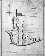
Sketch of the south lawn From at least the mid-15th century, the urban community which has developed into modern Hamilton grew up alongside the residence of the Lords (later Dukes of) Hamilton, and was very much under their authority. From the late 17th century onwards, that authority began to have an impact on the actual layout of the burgh and its physical relationship to the nearby palace. It was made manifest in a long process involving the removal of the townspeople from the 'Hietoun' of Hamilton which was clustered around the palace's western doorstep, and the consolidation of the area as private parkland. This sketch of the south lawn of Hamilton Palace shows proposals for the creation of walkways and shrubberies in the areas to the south and west of the palace, recently made private by a re-routing of the Edinburgh road (bottom) and by walling off most of the 'Hietoun' (which stood roughly in the area occupied by the north point and the sketched walkways). A recently created drive leads to the palace from the Edinburgh road which swings across the line of the great avenue (centre) to a bridge over the River Clyde, instead of following a direct route across the front of the palace to the Clyde ferry. |
|||||||
|
The palace, about to be massively enlarged by the 10th Duke (1767-1852), is shown in its late 17th-century outline, with a conservatory sketched in on the east side, close to the site of the old part-dismantled church and burial aisle (not shown). The range running along the north side of the enclosed kitchen garden (bottom right) is marked 'Peach Houses, Vinery etc'. |
||||||||
|
|
|
|
|
|
|
|
|
|
 Detailed
view of the palace Detailed
view of the palace |
||||||||
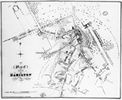
 William
Pettigrew plan, 1813 William
Pettigrew plan, 1813 |
||||||||
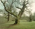
 Cadzow Oaks |
 Engraving
by John Slezer Engraving
by John Slezer |
|||||||
|
|
|
|
|
|
|
|
|
|

