| Glasgow Digital Library | Voyage of the Scotia | BRUCE | PEOPLE | SHIP | ANTARCTIC | INDEX |
|---|
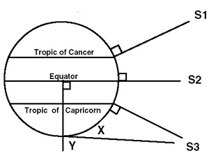
The calculation of latitude by taking an altitude of the sun above the horizon has been possible for several hundred years. The compilation of nautical almanacs made the calculations fairly simple: the tables show where the sun is overhead at any time of the year.
S1 sun overhead 21 June 23.5°N
S2 sun overhead 21 March and 21 September
S3 sun overhead 21 December 23.5°S
The latitude of the overhead sun north and south of the equator is called the declination. This can be found in nautical almanacs. When the sun is overhead on 21 December the declination is 23.5°S but the altitude of the sun at the South Pole (angle X) is also 23.5°. Only when at the South Pole is the declination the same as the true altitude.
Once the angle of the sun above the horizon is taken, several corrections are made - for error of the sextant, parallax, height of the observer and diameter of the sun.
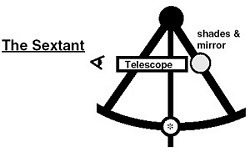
The altitude of the sun above the horizon can be measured with a sextant. The sun is observed through the telescope (fitted with shades) and it is brought down to the horizon by swinging the central arm. The angle is measured at *.
Before sailors could calculate longitude, they sailed north or south until they reached the parallel of latitude of their destination - then they sailed along that parallel. Accurate clocks were available from the end of the 18th century and these meant that longitude could then be calculated.
Harrison's clocks made between 1737 and 1760 were the first accurate clocks (chronometers) which enabled sailors to calculate longitude. If a chronometer has an error of four seconds then the longitude calculated will be incorrect by one mile. (18° longitude = 12 hours' time)
The measurement of the altitude of a heavenly body is only possible if you can see the horizon. This is not always possible (in poor weather) and Antarctic explorers carried an artificial horizon - a special box with bath of mercury and mirrors.
The accuracy of an observation of the sun depends on conditions. Even in good weather, observations of the sun may provide a position a few miles out. Amundsen walked 12 miles around the South Pole to be sure he was there. Scott had no difficulty finding Amundsen's tent at the South Pole.
Today, by pressing a button on a GPS, it is possible to precisely read a position. In the Antarctic, batteries in the GPS must be kept warm for them to work.
| Observed altitude | 22°42.8' |
| Corrections | +17.2' |
| True Altitude | 23°30' |
| Zenith Distance Y | 66°30' |
| Declination | 23°30' |
| Latitude | 90°S |
When Scott was at the South Pole the altitude of the sun was 21°31.1'. The declination was also 21° 31.1'.
| Glasgow Digital Library | Voyage of the Scotia | BRUCE | PEOPLE | SHIP | ANTARCTIC | INDEX |
|---|

