| Glasgow Digital Library | Voyage of the Scotia | BRUCE | PEOPLE | SHIP | ANTARCTIC | INDEX |
|---|
When volcanic and sedimentary rocks form, their minerals take on the magnetic orientation of that time. Study of rocks can therefore tell us where the magnetic poles were situated when the rocks were formed. This information was important in proving that the continents have moved around the surface of the globe.
Another major discovery from the study of the magnetism of rocks is that at times the Earth's magnetic field has been very weak and every so many hundreds of thousands of years it has reversed. The last time this reversal occurred was about 700,000 years ago. The next? Maybe in a few thousand years.
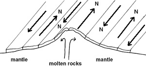
These changes are best shown on the floor of the Atlantic Ocean on either side of the Mid-Atlantic Ridge. As the North American and Eurasian plates have drifted apart, lava has poured out along the boundary - the youngest new rocks are near the centre and older rocks are furthest away from the plate boundary. When the magnetism of these rocks is examined, a bar pattern can be seen with rock's magnetism orientated to the north and south alternatively.
Magnetic surveys from aircraft and satellite (Magsat 1 was launched in 1979) help mapping the magnetic properties of the Earth. One of the important economic features of these surveys is the finding of minerals, particularly iron. A large body of iron can have an important local effect on magnetism.
The gyroscopic compass is based on the spinning wheel of a gyroscope, and always points to the axis of the Earth's rotation - the North Pole. The first gyroscopic compass was made by the German Dr Anchutz in 1908. In 1911 Dr E Sperry of the USA patented his gyroscope and five years later S Brown introduced a British version.
The first merchant ship to be fitted with a gyroscopic compass was the four-funnelled Cunard liner Aquitania in 1920. These compasses are only suitable for larger ships. A master compass is situated in the centre of gravity of the ship with repeaters in the navigation areas.
| Glasgow Digital Library | Voyage of the Scotia | BRUCE | PEOPLE | SHIP | ANTARCTIC | INDEX |
|---|

