| Glasgow Digital Library | Voyage of the Scotia | BRUCE | PEOPLE | SHIP | ANTARCTIC | INDEX |
|---|
On 23 March 1904 Scotia reached the spot where James Ross had recorded a depth of 4,000 fathoms in 1843. This reading had always been suspect and Bruce changed the map of the Weddell Sea by recording 2,660 fathoms.
Bad weather was to stop a lot of scientific work, but on 31 March Scotia recorded her greatest depth of 2,764 fathoms.
On 31 March the wind was blowing from the northwest and the ship was rolling 56° to starboard and 43° to port. No one could get any sleep. 'All this and dodging icebergs - at night!' Because of the adverse northwest winds a call at the South Sandwich Islands was ruled out and the decision was made to visit Gough Island. The last ice was seen on 5 April.
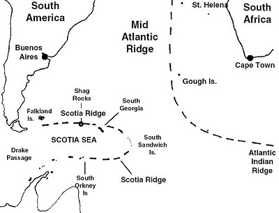
On 8 April, at 52°33'S 9°47'W, a sounding of 2,000 fathoms showed the continuation of the Mid Atlantic Ridge over 1,600km (1,000 miles) further south than previous records showed. The sounding was 2,000m (6,000 feet) above previous soundings.
Bruce's soundings changed the maps of the oceans in the area. The Scotia Ridge and the Scotia Sea were later named after his expedition's ship.
Hard work on the sounding machine
'The man that had to grease the wire is particularly unlucky; a perfect stream of ice cold water comes off the wire, soaks through the mittens and freezes hard, then, being out on the weather side, he gets well douched with spray and by the end of the time is thoroughly chilled, and more like an icicle than a sentient human being.'
| Glasgow Digital Library | Voyage of the Scotia | BRUCE | PEOPLE | SHIP | ANTARCTIC | INDEX |
|---|

