| Glasgow Digital Library | Voyage of the Scotia | BRUCE | PEOPLE | SHIP | ANTARCTIC | INDEX |
|---|
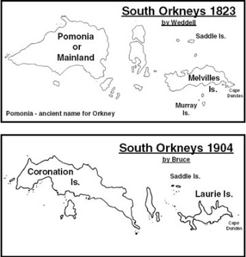
The South Orkney Islands were discovered in 1821 by the English sealer George Powell on the sloop Dove and the American sealer Nathaniel Palmer on James Monroe. This was in George IV's coronation year, so the larger island was called Coronation Island.
In 1823 the Scottish sealer James Weddell visited the islands. The 1823 map is Weddell's map of the South Orkney Islands. As he was being sponsored in part by the Admiralty he named the eastern island after the First Lord of the Admiralty, Lord Melville. A comparison of Weddell's map with the map by Bruce, and more recent maps, shows that the 1823 survey was very poor. Bruce's map, drawn almost 80 years later, had only three of the names shown on Weddell's map. Bruce reverted to the names given by Powell.
Bruce used more modern survey techniques, having had some training with the Ordnance Survey. Despite a broken theodolite, Bruce used triangulation techniques and a sextant to make a detailed map of Laurie Island.
Bruce established a meteorological station on Laurie Island at Scotia Bay. When Bruce left the island in 1904 for the last time, the station was left in the hands of Argentinian weather observers. This station continues to be operated by Argentina and is now (2003) the longest continuously occupied base in the Antarctic.
Bruce contacted the British government to see if they were interested in claiming the South Orkney Islands for the British Crown. At that time they were regarded as a worthless acquisition and only in 1908 were they made part of the Falkland Islands Dependencies (FIDS). In 1962 FIDS became the British Antarctic Survey (BAS).
Under the International Treaty of 1959 all territorial claims by the nations of the world have been set aside south of 60°S as the Antarctic has been opened up for scientific research (see section 7).
In 1947, FIDS established a base on Signy Island to study freshwater and terrestial ecosystems. This became a summer-only base in 1996.
The South Orkney Islands were virtually unknown scientifically when Bruce arrived in Scotia Bay. After Weddell's visit, there was a brief visit by Dumont d'Urville in 1838. He landed on Saddle Island and Weddell Island and cruised the coast of Coronation Island and Laurie Island. In 1893 Larsen on the whaler Jason landed on the island. Very little was known of the interior. The land of the South Orkney Islands is very steep-sided and rises to over 400 metres. Bold headlands, precipitous cliffs and deep valleys filled with glaciers do not make it the most attractive place for human habitation. There is very little flat land and the only beach of any size was at Scotia Bay. Around 90% of the island is ice-covered.
Scotia was anchored in 10 fathoms of water in a bay which shelved down to 50 fathoms. Fifteen miles off shore it was 1,746 fathoms. This fairly shallow water was ideal for winter quarters as the huge icebergs of the area would run aground before they reached Scotia.
The vegetation of Laurie Island was very sparse and consisted mainly of mosses and lichens. The sea life was the great interest - especially the birds and seals. Life on the island was at its peak in the spring when penguins came to nest and seals arrived with their pups.
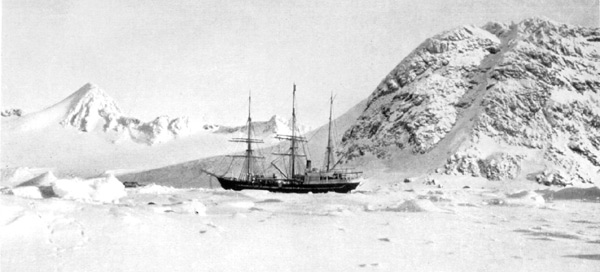
Scotia in Scotia Bay, Laurie Island, South Orkneys
| Glasgow Digital Library | Voyage of the Scotia | BRUCE | PEOPLE | SHIP | ANTARCTIC | INDEX |
|---|

