| |

© Country Life Picture Library |
|
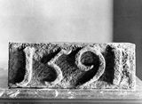
1591 datestone, c.1919
A medieval castle which now survives as a tree-shrouded
motte or earthwork mound to the north of the mausoleum was evidently
associated with Cadzow, a medieval settlement, which stood on the
river plain close to the confluence of the Cadzow Burn and the River
Clyde. By the later Middle Ages castle and town had shifted from
the 'Nethertoun' to the 'Hietoun' on the western edge of the plain.
The urban settlement became known as Hamilton and the stone-built
manorial residence of the Hamilton family came to be known variously
as The Orchard or the Castle of Hamilton, occasionally also referred
to as the 'Palace'. There seems little doubt that, probably from
the advent of the Hamiltons in the early 14th century, their principal
residence stood on the site which developed into Hamilton Palace.
|
|
| |
This 1591 datestone, which is carved in false
relief (that is, with raised figures) and recorded here in a photograph
of 1919, is a fragment of 'The Orchard' incorporated in the later
palace, possibly commemorating a phase of repair and enlargement
in the 1590s. Upon the demolition of the palace in the 1920s, the
remains of walls up to 2.7m thick, compared to 0.9m elsewhere, were
also encountered in the north-west quarter, strongly indicating
that this part of the building fabric was of pre-17th-century origin.
'The Orchard', together with what is today known
as Cadzow Castle, was the object of much destructive attention on
the part of royal armies in the period between 1565 and 1579 when
it frequently changed hands. It suffered damage in a siege of 1570
and again in 1579 on the occasion when Cadzow Castle was substantially
destroyed and left abandoned. However, symbolised as a grand and
noticeably broad and turreted structure on Timothy Pont's late 16th-century
map of Clydesdale, 'The Orchard' clearly soon revived from these
ordeals and is known to have accommodated King James VI himself
on a hunting trip in 1589.
|
|