|
|
|
| |
|
|
 |
| Holiday
Time |
| |
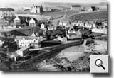
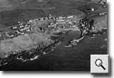
A view
of Collieston circa 1960. By the 1960’s Collieston
had become a popular destination for holidaymakers
and day-trippers. In the foreground there is clear
evidence that the foreshore is much less rocky than
it was at the beginning of the 20th Century and the
safe, sandy beach, which has gradually formed over
the years since the Pier was constructed in 1894,
was a great attraction for residents and tourists
alike.
To the rear of the photograph the manse, Slains Parish
Church and the old school, now used as the village
community centre, are clearly visible. Centre right
is the area of the village known as the Cliff and
the cottage which can be seen on the far right is
the one in which T E Lawrence stayed in 1930. Like
many of the other cottages in the village it has been
modernised and extended and is now harled and white
washed. |
|
|
| |
|
|
| |
|
|
| |
| Collieston
has always been a good location for press photographers
to capture some attractive “local colour”.
|
| |
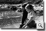
In this
shot from the Press & Journal, Collieston youngsters
Norman Moncrieff and Hazel Robertson strike a poetic
pose reminiscent of the “Boyhood of Raleigh”.
|
| |
|
 |
| |
|
|
| |
Shipping
on the Ythan Estuary |
|
 |
| |
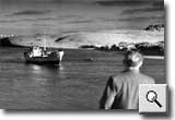
Until
1965, the Ythan estuary was dredged to allow small
coal boats to reach the Mitchell and Rae quay at Newburgh.
The small collier (reputedly on its last voyage) is
heading seaward past the extensive dune system at
the south end of the Forvie Nature Reserve.
A small pilot boat can be seen to port of the collier,
whilst to starboard a channel marker pole is visble.
The coal that was unloaded at the quay was graded
and stored in large bunkers. It was later bagged and
delivered by lorry to local communities including
Collieston.
By the 1990s the coal merchants had transferred their
business to the former brick works at Tipperty.
|
| |
|
|
| |
|
|
| |
| Coastguards |
| |
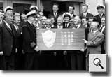
On December
16, 1966, the m.f.v. ‘Semnos II’ ran aground
on a sandbank, in heavy seas, about 500 yards north
of the River Ythan. Belhelvie and Collieston Auxiliary
Coastguard Companies were alerted and immediately
proceeded to the scene of the shipwreck where well-rehearsed
rescue procedures were put into operation.
The shield awarded by The Board of Trade for the best
wreck service of the year, was jointly awarded to
the Auxiliary Coastguard Companies of Belhelvie and
Collieston for their part in the successful rescue
of the six-man crew. The presentation was held the
following year at the New Inn, Ellon.
|
| |
|
 |
| |
|
|
| |
Aerial
View |
|
 |
| |
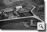
A general
view of Slains Estate in 1964 when it was sold by
Sir Ian Walker-Okeover to Sir Richard Sutton Settled
Estates. The Estate has a 5-mile frontage to the East
Coast of Scotland, immediately north of Newburgh and
bounded by the River Ythan Estuary on its southwest
side.
Comprising Forty-seven Mixed Farms ranging from 934
Acres to 5 Acres, the Estate also boasts Moorlands,
Lochs and Foreshore totalling 1,865 Acres, 6 Cottages
and the Sporting Rights over the whole Estate.
Many of the properties in Collieston, clearly visible
in the foreground above the coastline, are privately
owned but are required to pay Feu Duties to the Estate
in respect of small pieces of land sold in past years.
Some of the properties are still owned by the Estate
and rents, in respect of tenancies, are required to
be paid to the Estate.
|
| |
|
|
| |
|
|
| |
Education |
|
| |
| |
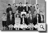
Pupils
of Slains School in 1961. The catchment area of the
school at that time was the Parish of Slains, including
Auchmacoy, Slains and Collieston. Many of the children
from Slains and Auchmacoy came from farming families
or from those families who worked on the Auchmacoy
Estate.
The Collieston children came from a variety of family
backgrounds with many of their parents working in
and around Aberdeen. The school building, visible
behind the group of children, was demolished in 1968
and replaced by a modern school building. |
| |
|
 |
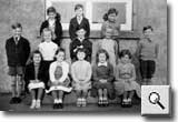 |
Pupils of Slains
School in 1961. The school had a staff of three full
time teachers and some 60-70 pupils whose families
were resident in Slains, Auchmacoy and Collieston.
Many of the children belonged to the local farming
community, while some of them were the children of
families who lived and worked on the nearby Auchmacoy
Estate.
The Collieston children came from a variety of family
backgrounds with many of their parents working in
and around Aberdeen.
The school building, visible behind the group of children,
was demolished in 1968 and replaced by a more modern
school building. |
|
|
| |
|
|
| |
|
|
| |
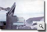
Old
Slains School was demolished in 1968. Clearly visible
behind the rubble of the old building is the new
school. The land occupied by the old school eventually
became
a playground for the pupils.
Already fully operational by the time the old school
was demolished, the school had a staff of three teachers
and some 60-70 pupils whose families were resident
in Slains, Auchmacoy and Collieston.
|
| |
|
 |
| |
|
|
 |
| Kirkton
Farm |
| |
Kirkton
Farm and Farm Buildings in 1964. Built of stone, with
a slate roof, the farmhouse comprises the following
accommodation: - Two sitting rooms, a kitchen, scullery
and milk room, four bedrooms, two boxrooms and a bathroom.
Situated a short distance away are the farm buildings
comprising a covered cattle court, two cow byres,
two barns, a root house, food store and loft, two
deep litter chicken houses and an old bothy, now used
for general storage purposes.
To the right of Kirkton Farm, Slains Parish Church
is clearly visible as is the Glebe, the L-shaped building
in the foreground.
|
| |
|
|
| |
|
|
| |
Slains
Estate |
|
| |
| |
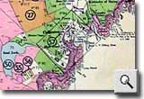
A plan
of Slains Estate with an inset plan of Collieston
Village
in 1964. On Thursday 16th July 1964, the Estate,
owned by Sir Ian Walker-Okeover since 1942, was
sold by
auction at The Station Hotel, Aberdeen to Sir Richard
Sutton Settled Estates.
On the Plan each Holding, some 58 in total, is clearly
identified by number and size. With a 5-mile frontage
to the East Coast of Aberdeenshire, immediately north
of Newburgh and bounded by the River Ythan Estuary
on its southwest side, Slains Estate comprises approximately
7,574 Acres.
There are Forty-seven Mixed Farms ranging from 934
Acres to 5 Acres, Moorlands, Lochs and Foreshore totalling
1,865 Acres, and 6 Cottages. It is worth noting that
only one Holding is located on the inset plan of Collieston
Village. ‘Louselaw’, Holding 57, is situated
in the centre of the village and was formerly the
Dairy.
|
| |
|
 |
| |
|
|
 |
| Slains
Parish Church |
| |
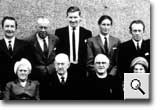
The minister
and elders of Slains Parish Church in 1967. The previous
year a law had been passed within the Church of Scotland
which permitted women to serve as elders for the first
time in its history.
The Rev John Murray, minister of Slains Church from
1947 until his retirement in 1972, was the last minister
of the Parish of Slains and the last minister to be
resident in Collieston. Soon after his retirement
the manse was sold as a private dwelling and the Parish
of Slains was united with the nearby Parish of Ellon.
|
| |
|
|
| |
|
|
| |
Gala
Day |
|
| |
| |
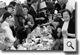
Gala Day
circa 1965. The Collieston Amenities Committee, which
organises the annual gala, was formed in 1957 with
the aim of raising money to finance the maintenance
of the Pier as well as the unique system of roadies
or paths that run throughout the village.
The first Gala Day to raise money for this conservation
task was held in 1958. The Pier was duly repaired
and Gala Day has been a feature of village life every
summer since.
Weather permitting, stalls are erected in the open
air along the Pier and harbour area of the village
but, when the weather is inclement, everything has
to be conducted under cover of the marquee.
|
| |
|
 |
|
 |
|
| ....copyright
collieston's century 2003 |
|